


Lacs Lauzon et Bleu

GOHIER
User
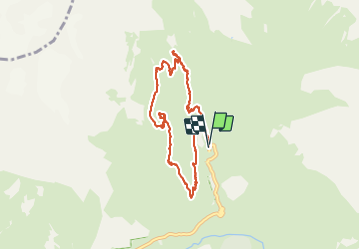

Length
8.7 km

Max alt
2186 m

Uphill gradient
595 m
Km-Effort
16.6 km

Min alt
1633 m

Downhill gradient
597 m
Boucle
Yes
Creation date :
2021-08-15 07:49:20.0
Updated on :
2021-08-15 14:26:57.584
6h34
Difficulty : Medium

FREE GPS app for hiking
 SityTrail
IGN / Geographical institutes
SityTrail Plus
The world is yours!
About
Trail Walking of 8.7 km to be discovered at Provence-Alpes-Côte d'Azur, Hautes-Alpes, La Chapelle-en-Valgaudémar. This trail is proposed by GOHIER.
Description
Belle boucle, baignade très agréable, avec les enfants. Chaud en août!
Positioning
Country:
France
Region :
Provence-Alpes-Côte d'Azur
Department/Province :
Hautes-Alpes
Municipality :
La Chapelle-en-Valgaudémar
Location:
Unknown
Start:(Dec)
Start:(UTM)
285114 ; 4968958 (32T) N.
Comments