


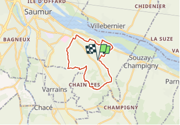
Entre Saumur & Champigny

JMCMoreau
User

Length
11.6 km

Max alt
94 m

Uphill gradient
183 m
Km-Effort
14 km

Min alt
24 m

Downhill gradient
183 m
Boucle
Yes
Creation date :
2021-08-15 16:14:00.193
Updated on :
2021-08-15 16:48:36.115
3h30
Difficulty : Easy

FREE GPS app for hiking
 SityTrail
IGN / Geographical institutes
SityTrail Plus
The world is yours!
About
Trail Walking of 11.6 km to be discovered at Pays de la Loire, Maine-et-Loire, Saumur. This trail is proposed by JMCMoreau.
Description
Balade sur la demi journée depuis Saumur vers les vignes de Champigny. Sans difficulté particulière. A faire en famille ou entre amis.
Positioning
Country:
France
Region :
Pays de la Loire
Department/Province :
Maine-et-Loire
Municipality :
Saumur
Location:
Unknown
Start:(Dec)
Start:(UTM)
724249 ; 5235747 (30T) N.
Comments