


Pécrot / Oud Heverlée de Philippe et Gaëlle

pasvraimec
User
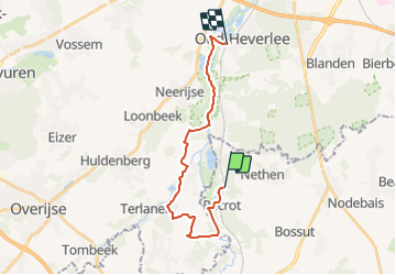

Length
17.6 km

Max alt
96 m

Uphill gradient
204 m
Km-Effort
20 km

Min alt
23 m

Downhill gradient
205 m
Boucle
No
Creation date :
2021-08-16 14:05:32.151
Updated on :
2021-08-16 14:07:28.114
4h37
Difficulty : Very difficult

FREE GPS app for hiking
 SityTrail
IGN / Geographical institutes
SityTrail Plus
The world is yours!
About
Trail Walking of 17.6 km to be discovered at Wallonia, Walloon Brabant, Grez-Doiceau. This trail is proposed by pasvraimec.
Description
le long de le Dyle et des étangs
Positioning
Country:
Belgium
Region :
Wallonia
Department/Province :
Walloon Brabant
Municipality :
Grez-Doiceau
Location:
Unknown
Start:(Dec)
Start:(UTM)
616433 ; 5626504 (31U) N.
Comments