


Étape 3 GR5 2021

Pascal Bernaud
User
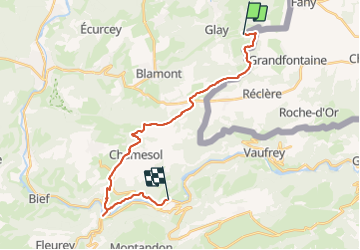

Length
23 km

Max alt
818 m

Uphill gradient
710 m
Km-Effort
33 km

Min alt
371 m

Downhill gradient
749 m
Boucle
No
Creation date :
2021-08-16 06:19:44.0
Updated on :
2021-08-16 14:38:22.404
8h16
Difficulty : Medium

FREE GPS app for hiking
 SityTrail
IGN / Geographical institutes
SityTrail Plus
The world is yours!
About
Trail Walking of 23 km to be discovered at Bourgogne-Franche-Comté, Doubs, Glay. This trail is proposed by Pascal Bernaud.
Positioning
Country:
France
Region :
Bourgogne-Franche-Comté
Department/Province :
Doubs
Municipality :
Glay
Location:
Unknown
Start:(Dec)
Start:(UTM)
342192 ; 5252098 (32T) N.
Comments