


SityTrail - RB-HA-07 / Thuin / 2021-07-18 / 25 km

mozzipsc
User
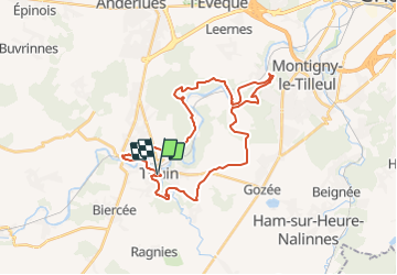

Length
30 km

Max alt
208 m

Uphill gradient
578 m
Km-Effort
38 km

Min alt
102 m

Downhill gradient
572 m
Boucle
Yes
Creation date :
2021-08-17 07:27:09.462
Updated on :
2021-08-17 13:45:30.33
8h50
Difficulty : Medium

FREE GPS app for hiking
 SityTrail
IGN / Geographical institutes
SityTrail Plus
The world is yours!
About
Trail Walking of 30 km to be discovered at Wallonia, Hainaut, Thuin. This trail is proposed by mozzipsc.
Positioning
Country:
Belgium
Region :
Wallonia
Department/Province :
Hainaut
Municipality :
Thuin
Location:
Unknown
Start:(Dec)
Start:(UTM)
591553 ; 5577176 (31U) N.
Comments