


Randonnée incomplète

Pascal Bernaud
User

Length
13.6 km

Max alt
917 m

Uphill gradient
706 m
Km-Effort
21 km

Min alt
387 m

Downhill gradient
246 m
Boucle
No
Creation date :
2021-08-17 07:15:12.0
Updated on :
2021-08-17 13:00:23.504
4h50
Difficulty : Very difficult

FREE GPS app for hiking
 SityTrail
IGN / Geographical institutes
SityTrail Plus
The world is yours!
About
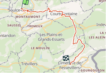
Trail Walking of 13.6 km to be discovered at Bourgogne-Franche-Comté, Doubs, Soulce-Cernay. This trail is proposed by Pascal Bernaud.
Positioning
Country:
France
Region :
Bourgogne-Franche-Comté
Department/Province :
Doubs
Municipality :
Soulce-Cernay
Location:
Unknown
Start:(Dec)
Start:(UTM)
338152 ; 5243529 (32T) N.
Comments