


2021-08-17_16h37m12_Foret de la Sine Tourette

GrouGary
User

Length
19.8 km

Max alt
413 m

Uphill gradient
707 m
Km-Effort
29 km

Min alt
151 m

Downhill gradient
709 m
Boucle
Yes
Creation date :
2021-08-17 14:37:13.011
Updated on :
2021-08-25 13:44:49.522
6h38
Difficulty : Medium

FREE GPS app for hiking
 SityTrail
IGN / Geographical institutes
SityTrail Plus
The world is yours!
About
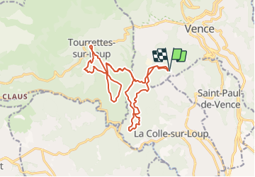
Trail On foot of 19.8 km to be discovered at Provence-Alpes-Côte d'Azur, Maritime Alps, Vence. This trail is proposed by GrouGary.
Description
Circuit en sous bois, sans difficultés, dans les 10 kms du point de départ. avril21
Positioning
Country:
France
Region :
Provence-Alpes-Côte d'Azur
Department/Province :
Maritime Alps
Municipality :
Vence
Location:
Unknown
Start:(Dec)
Start:(UTM)
346674 ; 4841133 (32T) N.
Comments