


cellettes

gerardh
User
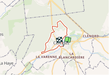

Length
9.3 km

Max alt
113 m

Uphill gradient
88 m
Km-Effort
10.5 km

Min alt
70 m

Downhill gradient
88 m
Boucle
Yes
Creation date :
2021-08-17 14:50:10.584
Updated on :
2021-08-17 14:51:49.985
2h23
Difficulty : Medium

FREE GPS app for hiking
 SityTrail
IGN / Geographical institutes
SityTrail Plus
The world is yours!
About
Trail Walking of 9.3 km to be discovered at Centre-Loire Valley, Loir-et-Cher, Cellettes. This trail is proposed by gerardh.
Description
par parc de beauregard
chateau de lutaine
ornay
Positioning
Country:
France
Region :
Centre-Loire Valley
Department/Province :
Loir-et-Cher
Municipality :
Cellettes
Location:
Unknown
Start:(Dec)
Start:(UTM)
378652 ; 5264777 (31T) N.
Comments