


ARAVIS: LES CONFINS - POINTE DE TARDEVANT retour par Bombardellaz

djeepee74
User
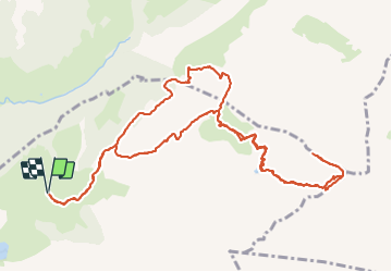

Length
14.4 km

Max alt
2485 m

Uphill gradient
1107 m
Km-Effort
29 km

Min alt
1441 m

Downhill gradient
1107 m
Boucle
Yes
Creation date :
2021-08-18 05:05:18.951
Updated on :
2021-08-19 14:22:53.559
6h00
Difficulty : Difficult

FREE GPS app for hiking
 SityTrail
IGN / Geographical institutes
SityTrail Plus
The world is yours!
About
Trail Walking of 14.4 km to be discovered at Auvergne-Rhône-Alpes, Upper Savoy, La Clusaz. This trail is proposed by djeepee74.
Description
BOUCLE... live 20210818
Positioning
Country:
France
Region :
Auvergne-Rhône-Alpes
Department/Province :
Upper Savoy
Municipality :
La Clusaz
Location:
Unknown
Start:(Dec)
Start:(UTM)
304907 ; 5088506 (32T) N.
Comments