


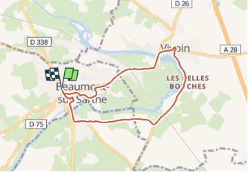
Boucle Beaumont Vivoin

Roulland
User

Length
7.2 km

Max alt
82 m

Uphill gradient
50 m
Km-Effort
7.8 km

Min alt
59 m

Downhill gradient
50 m
Boucle
Yes
Creation date :
2021-08-18 14:13:36.868
Updated on :
2021-08-18 15:40:57.631
1h20
Difficulty : Very easy

FREE GPS app for hiking
 SityTrail
IGN / Geographical institutes
SityTrail Plus
The world is yours!
About
Trail Walking of 7.2 km to be discovered at Pays de la Loire, Sarthe, Beaumont-sur-Sarthe. This trail is proposed by Roulland.
Photos


Positioning
Country:
France
Region :
Pays de la Loire
Department/Province :
Sarthe
Municipality :
Beaumont-sur-Sarthe
Location:
Unknown
Start:(Dec)
Start:(UTM)
286702 ; 5345521 (31U) N.
Comments