Trail Walking Saint-Julien-Vocance - Les Sources de la Cance - Saint-Julien-Vocance - Photo

Les Sources de la Cance - Saint-Julien-Vocance

© OpenStreetMap contributors
Length
Length
11.1 km
Max alt
Max alt
922 m
Uphill gradient
Uphill gradient
349 m
Km-Effort
Km-Effort  
15.7 km
Min alt
Min alt
653 m
Downhill gradient
Downhill gradient
341 m
Boucle
Boucle
Yes
Creation date :
2021-08-19 13:40:04.645
Updated on :
2021-08-19 14:00:10.018

(0 Reviews)

Walking
Walking
3h33
Difficulty : Difficult

Scan this QR Code to open this trail in the SityTrail application

FREE GPS app for hiking

Logo SityTrail SityTrail

IGN / Geographical institutes

Download SityTrail from the App Store Download SityTrail from Google Play

Logo SityTrail SityTrail World

The world is yours!

Download SityTrail from the App Store Download SityTrail from Google Play Download SityTrail on Huawei AppGallery

About

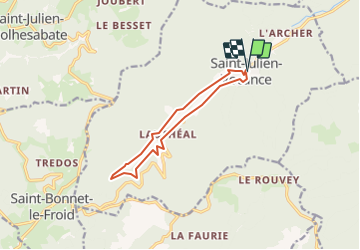
Trail Walking of 11.1 km to be discovered at Auvergne-Rhône-Alpes, Ardèche, Saint-Julien-Vocance. This trail is proposed by BiBiRando.

Description

1° Descendez la petite route en direction de la rivière.
2° Traverser la Cance et passez devant une scierie.
3° Gardez cette route pour remonter la rivière par sa rive gauche, Descendez la petite route en direction de la rivière.
4° Vous passez les lieux dits Pervenchère et Riboulon.
5° continuez le long à l'ombre, au bout vous retraversez la Cance et passez de l'adret à l'ubac.
6° Vous remontez jusqu'au au point le plus haut à 900 m d'altitude.
7° La piste s'assombrit et vous rejoignez le Lentier.
8° Remontez et prenez un chemin herbeux jusqu'à Lucas.
9° Traversez le ruisseau de l'Adret et passez devant une grande Maison Blanche.
10° Remontez la route puis descendez gauche pour rejoindre le village.

Elevation profile

Positioning

Country:
France
Region :
Auvergne-Rhône-Alpes
Department/Province :
Ardèche
Municipality :
Saint-Julien-Vocance
Location:
Unknown
Start:(UTM)
618072 ; 5003470 (31T) N.

Trails nearby

Trail Walking Monestier - 3 tournon lalizolle - Photo
Walking
aldaus

Walking

Medium
Monestier, Auvergne-Rhône-Alpes, Ardèche, France
34 km | 49 km-effort
9h 8min
No
Trail Walking Monestier - 07 le monestier 23.04.2017 - Photo
Walking
himba26100

Walking

Medium
Monestier, Auvergne-Rhône-Alpes, Ardèche, France
19 km | 29 km-effort
6h 16min
Yes
Trail Motor Vocance - Croix_Boray - Photo
Motor
astronaef

Motor

Medium
Vocance, Auvergne-Rhône-Alpes, Ardèche, France
9.4 km | 16.4 km-effort
Unknown
No
Trail Walking Monestier - Gd_Feuilletin - Photo
Walking
astronaef

Walking

Medium
(1)
Monestier, Auvergne-Rhône-Alpes, Ardèche, France
5.7 km | 8 km-effort
Unknown
Yes
Trail Motor Saint-Julien-Molhesabate - entourloop - Photo
Motor
astronaef

Motor

Medium
Saint-Julien-Molhesabate, Auvergne-Rhône-Alpes, Haute-Loire, France
21 km | 28 km-effort
Unknown
Yes
Trail Walking Vocance - D - Photo
Walking
raygautier

Walking

Difficult
Vocance, Auvergne-Rhône-Alpes, Ardèche, France
10.8 km | 13.7 km-effort
2h 17min
No
Trail Motorbike Vocance - Lozère jour 1 - Photo
Motorbike
luky0007

Motorbike

Easy
Vocance, Auvergne-Rhône-Alpes, Ardèche, France
238 km | 304 km-effort
5h 0min
No
Trail Walking Vocance - roche des vents - Photo
Walking
vanaud

Walking

Very easy
Vocance, Auvergne-Rhône-Alpes, Ardèche, France
19.6 km | 28 km-effort
5h 43min
Yes
Trail Walking Vocance - balade à vocance - Photo
Walking
luky0007

Walking

Easy
Vocance, Auvergne-Rhône-Alpes, Ardèche, France
2.5 km | 3.6 km-effort
1h 5min
Yes


Close
My subscriptions