


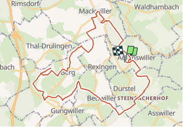
Boucle Adamswiller Kirschberg

Tourisme Equestre Alsace
Promouvoir le Tourisme Equestre en Alsace GUIDE+


3h53
Difficulty : Medium

FREE GPS app for hiking
 SityTrail
IGN / Geographical institutes
SityTrail Plus
The world is yours!
About
Trail Horseback riding of 24 km to be discovered at Grand Est, Bas-Rhin, Adamswiller. This trail is proposed by Tourisme Equestre Alsace.
Description
Boucle au départ et à l'arrivée d'Adamswiller avec pause pique-nique au milieu du parcours au Kirschberg avec sa barre d'attaches
Photos


Positioning
Comments