


Longemer J2

LauVan
User
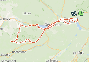

Length
40 km

Max alt
914 m

Uphill gradient
870 m
Km-Effort
52 km

Min alt
625 m

Downhill gradient
872 m
Boucle
Yes
Creation date :
2021-08-20 08:52:33.137
Updated on :
2021-08-20 12:48:45.697
3h55
Difficulty : Medium

FREE GPS app for hiking
 SityTrail
IGN / Geographical institutes
SityTrail Plus
The world is yours!
About
Trail Mountain bike of 40 km to be discovered at Grand Est, Vosges, Xonrupt-Longemer. This trail is proposed by LauVan.
Positioning
Country:
France
Region :
Grand Est
Department/Province :
Vosges
Municipality :
Xonrupt-Longemer
Location:
Unknown
Start:(Dec)
Start:(UTM)
347134 ; 5327649 (32U) N.
Comments