


arrêts le pic G3 2021

LouisROGER
User GUIDE
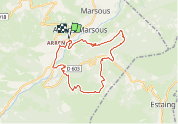

Length
9.4 km

Max alt
1353 m

Uphill gradient
524 m
Km-Effort
16.4 km

Min alt
861 m

Downhill gradient
524 m
Boucle
Yes
Creation date :
2021-08-20 07:18:30.246
Updated on :
2021-08-20 13:14:00.277
5h54
Difficulty : Difficult

FREE GPS app for hiking
 SityTrail
IGN / Geographical institutes
SityTrail Plus
The world is yours!
About
Trail Walking of 9.4 km to be discovered at Occitania, Hautespyrenees, Arrens-Marsous. This trail is proposed by LouisROGER.
Positioning
Country:
France
Region :
Occitania
Department/Province :
Hautespyrenees
Municipality :
Arrens-Marsous
Location:
Unknown
Start:(Dec)
Start:(UTM)
727530 ; 4759836 (30T) N.
Comments