MAINCY

jcschubnel
User
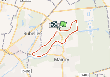

Length
5.6 km

Max alt
87 m

Uphill gradient
60 m
Km-Effort
6.4 km

Min alt
42 m

Downhill gradient
65 m
Boucle
Yes
Creation date :
2021-08-20 13:32:45.993
Updated on :
2021-08-20 15:39:11.318
1h23
Difficulty : Medium

FREE GPS app for hiking
 SityTrail
IGN / Geographical institutes
SityTrail Plus
The world is yours!
About
Trail Walking of 5.6 km to be discovered at Ile-de-France, Seine-et-Marne, Maincy. This trail is proposed by jcschubnel.
Positioning
Country:
France
Region :
Ile-de-France
Department/Province :
Seine-et-Marne
Municipality :
Maincy
Location:
Unknown
Start:(Dec)
Start:(UTM)
477675 ; 5378580 (31U) N.
Comments