


2021-08-20 15:43:25

mitch1952
User
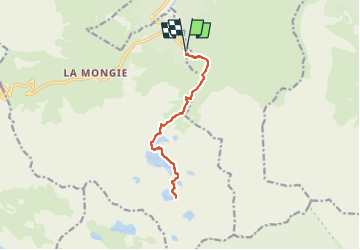

Length
13.6 km

Max alt
2229 m

Uphill gradient
879 m
Km-Effort
25 km

Min alt
1423 m

Downhill gradient
878 m
Boucle
Yes
Creation date :
2021-08-20 17:06:10.132
Updated on :
2022-06-08 14:22:27.903
5h45
Difficulty : Very difficult

FREE GPS app for hiking
 SityTrail
IGN / Geographical institutes
SityTrail Plus
The world is yours!
About
Trail Walking of 13.6 km to be discovered at Occitania, Hautespyrenees, Bagnères-de-Bigorre. This trail is proposed by mitch1952.
Positioning
Country:
France
Region :
Occitania
Department/Province :
Hautespyrenees
Municipality :
Bagnères-de-Bigorre
Location:
Unknown
Start:(Dec)
Start:(UTM)
272203 ; 4755413 (31T) N.
Comments