


variante

azipat
User
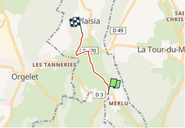

Length
2.4 km

Max alt
531 m

Uphill gradient
77 m
Km-Effort
3.2 km

Min alt
458 m

Downhill gradient
5 m
Boucle
No
Creation date :
2021-08-21 07:21:59.23
Updated on :
2021-08-21 07:22:02.515
1m
Difficulty : Very easy

FREE GPS app for hiking
 SityTrail
IGN / Geographical institutes
SityTrail Plus
The world is yours!
About
Trail Coupling of 2.4 km to be discovered at Bourgogne-Franche-Comté, Jura, Plaisia. This trail is proposed by azipat.
Positioning
Country:
France
Region :
Bourgogne-Franche-Comté
Department/Province :
Jura
Municipality :
Plaisia
Location:
Unknown
Start:(Dec)
Start:(UTM)
702429 ; 5154811 (31T) N.
Comments