


Fontevraud: le bourg, la forêt

JMCMoreau
User
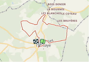

Length
8.5 km

Max alt
112 m

Uphill gradient
137 m
Km-Effort
10.3 km

Min alt
43 m

Downhill gradient
136 m
Boucle
Yes
Creation date :
2021-08-21 07:29:58.329
Updated on :
2021-08-21 07:31:43.189
3h00
Difficulty : Easy

FREE GPS app for hiking
 SityTrail
IGN / Geographical institutes
SityTrail Plus
The world is yours!
About
Trail Walking of 8.5 km to be discovered at Pays de la Loire, Maine-et-Loire, Fontevraud-l'Abbaye. This trail is proposed by JMCMoreau.
Description
Boucle sans difficulté en partie sur les routes et sentiers.
Positioning
Country:
France
Region :
Pays de la Loire
Department/Province :
Maine-et-Loire
Municipality :
Fontevraud-l'Abbaye
Location:
Unknown
Start:(Dec)
Start:(UTM)
276265 ; 5229513 (31T) N.
Comments