


Compostelle - Camino Frances : J11 de Atapuerca à Tardajos

webmammuth
User
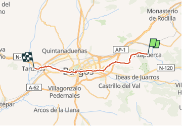

Length
33 km

Max alt
1074 m

Uphill gradient
287 m
Km-Effort
37 km

Min alt
823 m

Downhill gradient
413 m
Boucle
No
Creation date :
2021-08-21 06:33:00.068
Updated on :
2021-08-21 18:33:01.963
10h13
Difficulty : Medium

FREE GPS app for hiking
 SityTrail
IGN / Geographical institutes
SityTrail Plus
The world is yours!
About
Trail Walking of 33 km to be discovered at Castile and León, Unknown, Atapuerca. This trail is proposed by webmammuth.
Description
Compostelle - Camino Frances : J11 de Atapuerca à Tardajos
Positioning
Country:
Spain
Region :
Castile and León
Department/Province :
Unknown
Municipality :
Atapuerca
Location:
Unknown
Start:(Dec)
Start:(UTM)
458157 ; 4691761 (30T) N.
Comments