


ETREMBIERES LE SALEVE LE SAPPEY LA CROISETTE

leclaude74
User
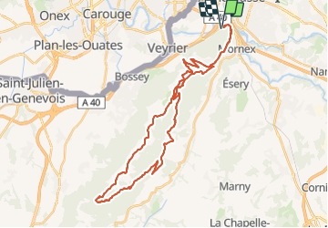

Length
38 km

Max alt
1350 m

Uphill gradient
1502 m
Km-Effort
58 km

Min alt
425 m

Downhill gradient
1500 m
Boucle
Yes
Creation date :
2021-08-22 06:35:39.598
Updated on :
2021-08-23 19:36:55.348
3h44
Difficulty : Difficult

FREE GPS app for hiking
 SityTrail
IGN / Geographical institutes
SityTrail Plus
The world is yours!
About
Trail Mountain bike of 38 km to be discovered at Auvergne-Rhône-Alpes, Upper Savoy, Étrembières. This trail is proposed by leclaude74.
Photos


Positioning
Country:
France
Region :
Auvergne-Rhône-Alpes
Department/Province :
Upper Savoy
Municipality :
Étrembières
Location:
Unknown
Start:(Dec)
Start:(UTM)
285960 ; 5117436 (32T) N.
Comments