


compiegne ete2021

verozerr
User
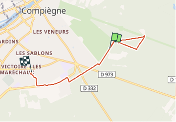

Length
5.1 km

Max alt
73 m

Uphill gradient
49 m
Km-Effort
5.8 km

Min alt
51 m

Downhill gradient
54 m
Boucle
No
Creation date :
2021-08-22 13:39:37.697
Updated on :
2021-08-22 14:42:26.214
54m
Difficulty : Easy

FREE GPS app for hiking
 SityTrail
IGN / Geographical institutes
SityTrail Plus
The world is yours!
About
Trail Walking of 5.1 km to be discovered at Hauts-de-France, Oise, Compiègne. This trail is proposed by verozerr.
Description
Compiègne en aout
Positioning
Country:
France
Region :
Hauts-de-France
Department/Province :
Oise
Municipality :
Compiègne
Location:
Unknown
Start:(Dec)
Start:(UTM)
489089 ; 5472960 (31U) N.
Comments