


rando 1b

Jose2401
User
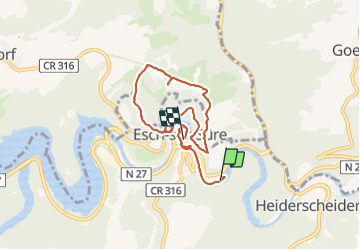

Length
7.1 km

Max alt
477 m

Uphill gradient
291 m
Km-Effort
11 km

Min alt
271 m

Downhill gradient
285 m
Boucle
No
Creation date :
2021-08-22 08:47:12.682
Updated on :
2021-08-22 15:27:01.753
2h31
Difficulty : Difficult

FREE GPS app for hiking
 SityTrail
IGN / Geographical institutes
SityTrail Plus
The world is yours!
About
Trail Walking of 7.1 km to be discovered at Unknown, Canton Wiltz, Esch-sur-Sûre. This trail is proposed by Jose2401.
Description
Randonnée difficile à Esch-sur-sure
Photos


Positioning
Country:
Luxembourg
Region :
Unknown
Department/Province :
Canton Wiltz
Municipality :
Esch-sur-Sûre
Location:
Unknown
Start:(Dec)
Start:(UTM)
711239 ; 5532347 (31U) N.
Comments