


Hom_Causse_Mejean

jagarnier
User GUIDE
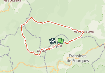

Length
16.8 km

Max alt
1169 m

Uphill gradient
382 m
Km-Effort
22 km

Min alt
1061 m

Downhill gradient
382 m
Boucle
Yes
Creation date :
2021-08-23 10:26:53.328
Updated on :
2021-08-24 04:42:20.339
5h45
Difficulty : Medium

FREE GPS app for hiking
 SityTrail
IGN / Geographical institutes
SityTrail Plus
The world is yours!
About
Trail Walking of 16.8 km to be discovered at Occitania, Lozère, Fraissinet-de-Fourques. This trail is proposed by jagarnier.
Positioning
Country:
France
Region :
Occitania
Department/Province :
Lozère
Municipality :
Fraissinet-de-Fourques
Location:
Unknown
Start:(Dec)
Start:(UTM)
541049 ; 4896919 (31T) N.
Comments