


Pargny la Dhuys du 24-08-2021

VANDERPUTTENMi
User GUIDE
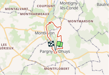

Length
8 km

Max alt
185 m

Uphill gradient
131 m
Km-Effort
9.8 km

Min alt
102 m

Downhill gradient
132 m
Boucle
Yes
Creation date :
2021-08-24 07:05:35.001
Updated on :
2021-08-24 17:50:39.337
2h05
Difficulty : Medium

FREE GPS app for hiking
 SityTrail
IGN / Geographical institutes
SityTrail Plus
The world is yours!
About
Trail Walking of 8 km to be discovered at Hauts-de-France, Aisne, Pargny-la-Dhuys. This trail is proposed by VANDERPUTTENMi.
Photos


Positioning
Country:
France
Region :
Hauts-de-France
Department/Province :
Aisne
Municipality :
Pargny-la-Dhuys
Location:
Unknown
Start:(Dec)
Start:(UTM)
540426 ; 5422276 (31U) N.
Comments