


2408

AMOURETTE
User
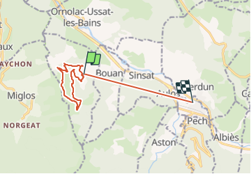

Length
12.9 km

Max alt
1204 m

Uphill gradient
567 m
Km-Effort
22 km

Min alt
521 m

Downhill gradient
955 m
Boucle
No
Creation date :
2021-08-24 07:21:58.712
Updated on :
2021-08-24 13:24:15.434
2h56
Difficulty : Very difficult

FREE GPS app for hiking
 SityTrail
IGN / Geographical institutes
SityTrail Plus
The world is yours!
About
Trail Walking of 12.9 km to be discovered at Occitania, Ariège, Larnat. This trail is proposed by AMOURETTE.
Positioning
Country:
France
Region :
Occitania
Department/Province :
Ariège
Municipality :
Larnat
Location:
Unknown
Start:(Dec)
Start:(UTM)
388164 ; 4739430 (31T) N.
Comments