


Lac de la Conche

supercolas
User GUIDE
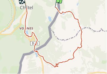

Length
9.9 km

Max alt
1790 m

Uphill gradient
207 m
Km-Effort
14.1 km

Min alt
1194 m

Downhill gradient
648 m
Boucle
No
Creation date :
2021-08-25 08:55:24.334
Updated on :
2021-08-25 14:55:44.958
4h06
Difficulty : Medium

FREE GPS app for hiking
 SityTrail
IGN / Geographical institutes
SityTrail Plus
The world is yours!
About
Trail Walking of 9.9 km to be discovered at Auvergne-Rhône-Alpes, Upper Savoy, Châtel. This trail is proposed by supercolas.
Description
Morgins
Positioning
Country:
France
Region :
Auvergne-Rhône-Alpes
Department/Province :
Upper Savoy
Municipality :
Châtel
Location:
Unknown
Start:(Dec)
Start:(UTM)
334930 ; 5125996 (32T) N.
Comments