


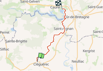
GR_37_DF_26_Cleguerec_Guerledan_20210828

patrickdanilo
User

Length
16.2 km

Max alt
169 m

Uphill gradient
280 m
Km-Effort
20 km

Min alt
75 m

Downhill gradient
309 m
Boucle
No
Creation date :
2021-08-27 08:47:50.649
Updated on :
2022-02-09 13:50:56.866
4h02
Difficulty : Very difficult

FREE GPS app for hiking
 SityTrail
IGN / Geographical institutes
SityTrail Plus
The world is yours!
About
Trail Walking of 16.2 km to be discovered at Brittany, Morbihan, Cléguérec. This trail is proposed by patrickdanilo.
Description
GR®37
Cœur de la Bretagne
Du Mont-Saint-Michel (Manche) Normandie
à Camaret-sur-Mer (Finistère) Bretagne
780km
Photos


Positioning
Country:
France
Region :
Brittany
Department/Province :
Morbihan
Municipality :
Cléguérec
Location:
Unknown
Start:(Dec)
Start:(UTM)
494126 ; 5330509 (30U) N.
Comments