


Lac St Apollinaire

Specialized77
User GUIDE
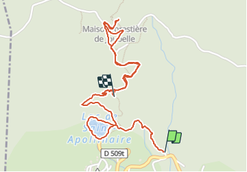

Length
3 km

Max alt
1668 m

Uphill gradient
256 m
Km-Effort
6 km

Min alt
1420 m

Downhill gradient
143 m
Boucle
No
Creation date :
2021-08-28 08:20:29.276
Updated on :
2021-09-01 07:43:07.354
3h42
Difficulty : Medium

FREE GPS app for hiking
 SityTrail
IGN / Geographical institutes
SityTrail Plus
The world is yours!
About
Trail Walking of 3 km to be discovered at Provence-Alpes-Côte d'Azur, Hautes-Alpes, Saint-Apollinaire. This trail is proposed by Specialized77.
Photos


Positioning
Country:
France
Region :
Provence-Alpes-Côte d'Azur
Department/Province :
Hautes-Alpes
Municipality :
Saint-Apollinaire
Location:
Unknown
Start:(Dec)
Start:(UTM)
289567 ; 4937672 (32T) N.
Comments