


col de la cayolle

BELLETGE
User

Length
74 km

Max alt
2331 m

Uphill gradient
2010 m
Km-Effort
101 km

Min alt
1056 m

Downhill gradient
2002 m
Boucle
Yes
Creation date :
2021-08-28 07:11:30.987
Updated on :
2021-08-28 12:05:42.02
4h30
Difficulty : Medium

FREE GPS app for hiking
 SityTrail
IGN / Geographical institutes
SityTrail Plus
The world is yours!
About
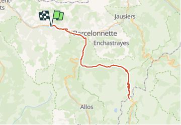
Trail Road bike of 74 km to be discovered at Provence-Alpes-Côte d'Azur, Alpes-de-Haute-Provence, Méolans-Revel. This trail is proposed by BELLETGE.
Positioning
Country:
France
Region :
Provence-Alpes-Côte d'Azur
Department/Province :
Alpes-de-Haute-Provence
Municipality :
Méolans-Revel
Location:
Unknown
Start:(Dec)
Start:(UTM)
303554 ; 4919010 (32T) N.
Comments