


sauve

Bwattier
User
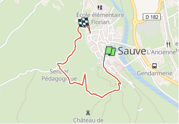

Length
1.5 km

Max alt
154 m

Uphill gradient
32 m
Km-Effort
1.9 km

Min alt
115 m

Downhill gradient
39 m
Boucle
No
Creation date :
2021-08-29 08:08:30.344
Updated on :
2021-08-29 09:51:54.219
39m
Difficulty : Easy

FREE GPS app for hiking
 SityTrail
IGN / Geographical institutes
SityTrail Plus
The world is yours!
About
Trail Walking of 1.5 km to be discovered at Occitania, Gard, Sauve. This trail is proposed by Bwattier.
Positioning
Country:
France
Region :
Occitania
Department/Province :
Gard
Municipality :
Sauve
Location:
Unknown
Start:(Dec)
Start:(UTM)
576150 ; 4865643 (31T) N.
Comments