


Hanches Droue sur Drouette

topophil
User
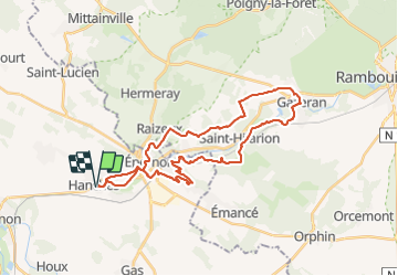

Length
32 km

Max alt
176 m

Uphill gradient
433 m
Km-Effort
38 km

Min alt
109 m

Downhill gradient
434 m
Boucle
Yes
Creation date :
2021-08-29 07:06:14.982
Updated on :
2021-08-29 10:17:39.397
2h37
Difficulty : Difficult

FREE GPS app for hiking
 SityTrail
IGN / Geographical institutes
SityTrail Plus
The world is yours!
About
Trail Mountain bike of 32 km to be discovered at Centre-Loire Valley, Eure-et-Loir, Hanches. This trail is proposed by topophil.
Positioning
Country:
France
Region :
Centre-Loire Valley
Department/Province :
Eure-et-Loir
Municipality :
Hanches
Location:
Unknown
Start:(Dec)
Start:(UTM)
400091 ; 5383833 (31U) N.
Comments