


Lans en Vercors... Le belvédère

PatriceCocuaud
User
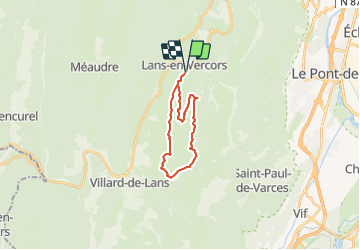

Length
18.2 km

Max alt
1440 m

Uphill gradient
531 m
Km-Effort
25 km

Min alt
1009 m

Downhill gradient
531 m
Boucle
Yes
Creation date :
2021-08-30 09:21:45.427
Updated on :
2021-08-30 13:29:35.691
4h07
Difficulty : Medium

FREE GPS app for hiking
 SityTrail
IGN / Geographical institutes
SityTrail Plus
The world is yours!
About
Trail Mountain bike of 18.2 km to be discovered at Auvergne-Rhône-Alpes, Isère, Lans-en-Vercors. This trail is proposed by PatriceCocuaud.
Positioning
Country:
France
Region :
Auvergne-Rhône-Alpes
Department/Province :
Isère
Municipality :
Lans-en-Vercors
Location:
Unknown
Start:(Dec)
Start:(UTM)
703759 ; 5000001 (31T) N.
Comments