


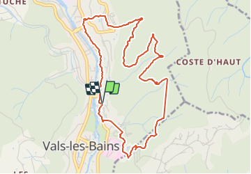
Vals (parcours santé)

Rudy07
User

Length
5.7 km

Max alt
401 m

Uphill gradient
191 m
Km-Effort
8.2 km

Min alt
250 m

Downhill gradient
189 m
Boucle
Yes
Creation date :
2021-08-30 12:25:05.171
Updated on :
2021-09-03 10:57:20.785
1h11
Difficulty : Very easy

FREE GPS app for hiking
 SityTrail
IGN / Geographical institutes
SityTrail Plus
The world is yours!
About
Trail Walking of 5.7 km to be discovered at Auvergne-Rhône-Alpes, Ardèche, Vals-les-Bains. This trail is proposed by Rudy07.
Positioning
Country:
France
Region :
Auvergne-Rhône-Alpes
Department/Province :
Ardèche
Municipality :
Vals-les-Bains
Location:
Unknown
Start:(Dec)
Start:(UTM)
608491 ; 4945984 (31T) N.
Comments