Trail Walking Saint-Pierre-d'Entremont - saint Christophe la boucle au départ de Saint Pierre d Entremont - Photo

saint Christophe la boucle au départ de Saint Pierre d Entremont

© OpenStreetMap contributors
Length
Length
11.7 km
Max alt
Max alt
1048 m
Uphill gradient
Uphill gradient
462 m
Km-Effort
Km-Effort  
17.9 km
Min alt
Min alt
650 m
Downhill gradient
Downhill gradient
462 m
Boucle
Boucle
Yes
Creation date :
2021-08-30 11:30:09.186
Updated on :
2021-08-30 16:13:26.466

(0 Reviews)

Walking
Walking
3h38
Difficulty : Easy

Scan this QR Code to open this trail in the SityTrail application

FREE GPS app for hiking

Logo SityTrail SityTrail

IGN / Geographical institutes

Download SityTrail from the App Store Download SityTrail from Google Play

Logo SityTrail SityTrail World

The world is yours!

Download SityTrail from the App Store Download SityTrail from Google Play Download SityTrail on Huawei AppGallery

About

Trail Walking of 11.7 km to be discovered at Auvergne-Rhône-Alpes, Isère, Saint-Pierre-d'Entremont. This trail is proposed by JamesVautier.

Description

retour rock'n'roll

Elevation profile

Photos

Positioning

Country:
France
Region :
Auvergne-Rhône-Alpes
Department/Province :
Isère
Municipality :
Saint-Pierre-d'Entremont
Location:
Unknown
Start:(UTM)
723367 ; 5033015 (31T) N.

Trails nearby

Trail Walking Saint-Pierre-d'Entremont - chartreuse varvats fouda blanc pinet - Photo
Walking
randochu

Walking

Difficult
(1)
Saint-Pierre-d'Entremont, Auvergne-Rhône-Alpes, Savoy, France
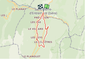
14.4 km | 27 km-effort
5h 27min
Yes
Trail Snowshoes Saint-Christophe-sur-Guiers - Le Belvédère d'Arpison - Photo
Snowshoes
patjobou

Snowshoes

Medium
(1)
Saint-Christophe-sur-Guiers, Auvergne-Rhône-Alpes, Isère, France
11.1 km | 17.4 km-effort
4h 43min
Yes
Trail Walking Saint-Pierre-d'Entremont - Le Grand Som 2026m, depuis Saint-Philibert - Photo
Walking
tracegps

Walking

Difficult
(1)
Saint-Pierre-d'Entremont, Auvergne-Rhône-Alpes, Isère, France
11.2 km | 25 km-effort
7h 0min
Yes
Trail Snowshoes Saint-Pierre-d'Entremont - La Croix de l'Alpe depuis les Varvats - Photo
Snowshoes
tracegps

Snowshoes

Medium
(1)
Saint-Pierre-d'Entremont, Auvergne-Rhône-Alpes, Savoy, France
12 km | 24 km-effort
5h 0min
Yes
Trail Walking Saint-Pierre-d'Entremont - Roche Veyrand par les Clapiers, 1429m - Photo
Walking
tracegps

Walking

Difficult
(1)
Saint-Pierre-d'Entremont, Auvergne-Rhône-Alpes, Savoy, France
4.8 km | 14.3 km-effort
4h 10min
Yes
Trail Walking Entremont-le-Vieux - Traversée du Mont Outheran 1676m - Photo
Walking
tracegps

Walking

Difficult
(1)
Entremont-le-Vieux, Auvergne-Rhône-Alpes, Savoy, France
9 km | 15.9 km-effort
3h 30min
Yes
Trail Walking Saint-Christophe-sur-Guiers - Petit Som 1772m,  depuis La Ruchère - Photo
Walking
tracegps

Walking

Medium
(2)
Saint-Christophe-sur-Guiers, Auvergne-Rhône-Alpes, Isère, France
6 km | 13.2 km-effort
3h 30min
Yes
Trail Walking Saint-Christophe-sur-Guiers - Petit Som par le Col de la Ruchère - Photo
Walking
simon.paume

Walking

Medium
(2)
Saint-Christophe-sur-Guiers, Auvergne-Rhône-Alpes, Isère, France
7.1 km | 15.2 km-effort
3h 5min
Yes
Trail Walking Entremont-le-Vieux - la Plagne le Pinet :en boucle partielle à  partir de la bifurcation GR9 et montée au Pinet - Photo
Walking
Valgaudemar

Walking

Medium
Entremont-le-Vieux, Auvergne-Rhône-Alpes, Savoy, France
12.9 km | 24 km-effort
3h 39min
Yes


Close
My subscriptions