


Semoy Bourg-Chalopinière

astro45
User
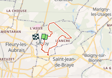

Length
10 km

Max alt
139 m

Uphill gradient
84 m
Km-Effort
11.1 km

Min alt
104 m

Downhill gradient
84 m
Boucle
Yes
Creation date :
2021-06-13 08:42:40.0
Updated on :
2022-04-27 22:02:12.751
1h57
Difficulty : Medium

FREE GPS app for hiking
 SityTrail
IGN / Geographical institutes
SityTrail Plus
The world is yours!
About
Trail Walking of 10 km to be discovered at Centre-Loire Valley, Loiret, Semoy. This trail is proposed by astro45.
Positioning
Country:
France
Region :
Centre-Loire Valley
Department/Province :
Loiret
Municipality :
Semoy
Location:
Unknown
Start:(Dec)
Start:(UTM)
421381 ; 5309414 (31T) N.
Comments