


reollon

BELLETGE
User
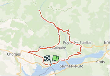

Length
45 km

Max alt
1482 m

Uphill gradient
1171 m
Km-Effort
60 km

Min alt
765 m

Downhill gradient
1171 m
Boucle
Yes
Creation date :
2021-08-31 07:36:17.234
Updated on :
2021-08-31 11:05:44.15
3h05
Difficulty : Medium

FREE GPS app for hiking
 SityTrail
IGN / Geographical institutes
SityTrail Plus
The world is yours!
About
Trail Road bike of 45 km to be discovered at Provence-Alpes-Côte d'Azur, Hautes-Alpes, Prunières. This trail is proposed by BELLETGE.
Positioning
Country:
France
Region :
Provence-Alpes-Côte d'Azur
Department/Province :
Hautes-Alpes
Municipality :
Prunières
Location:
Unknown
Start:(Dec)
Start:(UTM)
290297 ; 4933867 (32T) N.
Comments