


20210831 Pont St Pierre

Childebert
User
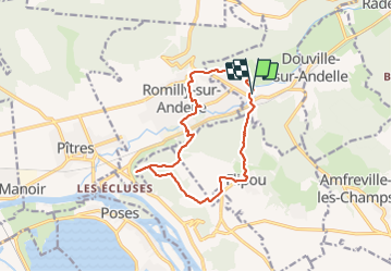

Length
12.5 km

Max alt
155 m

Uphill gradient
230 m
Km-Effort
15.6 km

Min alt
10 m

Downhill gradient
229 m
Boucle
Yes
Creation date :
2021-08-31 11:53:27.956
Updated on :
2021-08-31 15:29:03.052
3h34
Difficulty : Difficult

FREE GPS app for hiking
 SityTrail
IGN / Geographical institutes
SityTrail Plus
The world is yours!
About
Trail Walking of 12.5 km to be discovered at Normandy, Eure, Pont-Saint-Pierre. This trail is proposed by Childebert.
Positioning
Country:
France
Region :
Normandy
Department/Province :
Eure
Municipality :
Pont-Saint-Pierre
Location:
Unknown
Start:(Dec)
Start:(UTM)
375077 ; 5465829 (31U) N.
Comments