


Le Gué Poigny

topophil
User
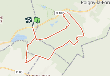

Length
9.3 km

Max alt
183 m

Uphill gradient
114 m
Km-Effort
10.8 km

Min alt
136 m

Downhill gradient
112 m
Boucle
Yes
Creation date :
2021-09-01 07:21:30.116
Updated on :
2021-09-01 09:40:29.603
2h06
Difficulty : Medium

FREE GPS app for hiking
 SityTrail
IGN / Geographical institutes
SityTrail Plus
The world is yours!
About
Trail Walking of 9.3 km to be discovered at Ile-de-France, Yvelines, Hermeray. This trail is proposed by topophil.
Positioning
Country:
France
Region :
Ile-de-France
Department/Province :
Yvelines
Municipality :
Hermeray
Location:
Unknown
Start:(Dec)
Start:(UTM)
405537 ; 5391191 (31U) N.
Comments