


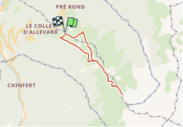
Belledonne Grand Charnier

c.gourme
User

Length
12.7 km

Max alt
2521 m

Uphill gradient
1088 m
Km-Effort
27 km

Min alt
1642 m

Downhill gradient
1090 m
Boucle
Yes
Creation date :
2021-09-01 06:34:40.0
Updated on :
2021-09-01 14:18:21.841
6h42
Difficulty : Medium

FREE GPS app for hiking
 SityTrail
IGN / Geographical institutes
SityTrail Plus
The world is yours!
About
Trail Walking of 12.7 km to be discovered at Auvergne-Rhône-Alpes, Isère, Allevard. This trail is proposed by c.gourme.
Description
Un peu vertigineux à faire par temps sec
Positioning
Country:
France
Region :
Auvergne-Rhône-Alpes
Department/Province :
Isère
Municipality :
Allevard
Location:
Unknown
Start:(Dec)
Start:(UTM)
275200 ; 5030649 (32T) N.
Comments