


cascade de la beaune

Dugourd
User

Length
13.1 km

Max alt
937 m

Uphill gradient
269 m
Km-Effort
16.7 km

Min alt
790 m

Downhill gradient
271 m
Boucle
Yes
Creation date :
2021-08-30 08:19:26.108
Updated on :
2021-09-03 10:26:43.612
4h00
Difficulty : Easy

FREE GPS app for hiking
 SityTrail
IGN / Geographical institutes
SityTrail Plus
The world is yours!
About
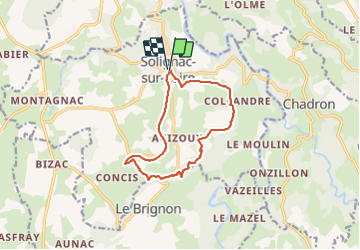
Trail Walking of 13.1 km to be discovered at Auvergne-Rhône-Alpes, Haute-Loire, Solignac-sur-Loire. This trail is proposed by Dugourd.
Positioning
Country:
France
Region :
Auvergne-Rhône-Alpes
Department/Province :
Haute-Loire
Municipality :
Solignac-sur-Loire
Location:
Unknown
Start:(Dec)
Start:(UTM)
569989 ; 4979780 (31T) N.
Comments