


sortie avec Patrick

bernardcornu
User
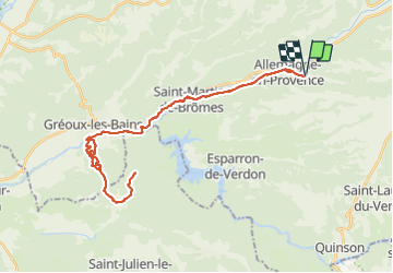

Length
42 km

Max alt
584 m

Uphill gradient
802 m
Km-Effort
53 km

Min alt
298 m

Downhill gradient
802 m
Boucle
Yes
Creation date :
2021-09-03 06:27:27.481
Updated on :
2021-09-03 11:40:36.342
3h10
Difficulty : Medium

FREE GPS app for hiking
 SityTrail
IGN / Geographical institutes
SityTrail Plus
The world is yours!
About
Trail Mountain bike of 42 km to be discovered at Provence-Alpes-Côte d'Azur, Alpes-de-Haute-Provence, Allemagne-en-Provence. This trail is proposed by bernardcornu.
Positioning
Country:
France
Region :
Provence-Alpes-Côte d'Azur
Department/Province :
Alpes-de-Haute-Provence
Municipality :
Allemagne-en-Provence
Location:
Unknown
Start:(Dec)
Start:(UTM)
260051 ; 4851738 (32T) N.
Comments