


Lans en Vercors la rouge shuntée et la bleue

PatriceCocuaud
User
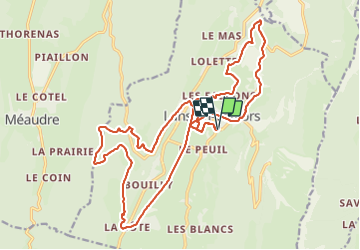

Length
25 km

Max alt
1285 m

Uphill gradient
610 m
Km-Effort
33 km

Min alt
979 m

Downhill gradient
610 m
Boucle
Yes
Creation date :
2021-09-03 08:53:09.101
Updated on :
2021-09-03 11:56:13.599
3h02
Difficulty : Medium

FREE GPS app for hiking
 SityTrail
IGN / Geographical institutes
SityTrail Plus
The world is yours!
About
Trail Mountain bike of 25 km to be discovered at Auvergne-Rhône-Alpes, Isère, Lans-en-Vercors. This trail is proposed by PatriceCocuaud.
Positioning
Country:
France
Region :
Auvergne-Rhône-Alpes
Department/Province :
Isère
Municipality :
Lans-en-Vercors
Location:
Unknown
Start:(Dec)
Start:(UTM)
703816 ; 5000027 (31T) N.
Comments