


Villefranche loc

xcreator
User
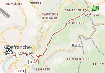

Length
6.3 km

Max alt
497 m

Uphill gradient
68 m
Km-Effort
7.9 km

Min alt
255 m

Downhill gradient
274 m
Boucle
No
Creation date :
2021-09-03 09:16:51.441
Updated on :
2021-09-03 15:43:34.498
1h44
Difficulty : Medium

FREE GPS app for hiking
 SityTrail
IGN / Geographical institutes
SityTrail Plus
The world is yours!
About
Trail Walking of 6.3 km to be discovered at Occitania, Aveyron, Maleville. This trail is proposed by xcreator.
Description
travers les collines
Positioning
Country:
France
Region :
Occitania
Department/Province :
Aveyron
Municipality :
Maleville
Location:
Unknown
Start:(Dec)
Start:(UTM)
426774 ; 4913011 (31T) N.
Comments