


Cuisiat - Nivigne - Mt Myon

CLP01
User
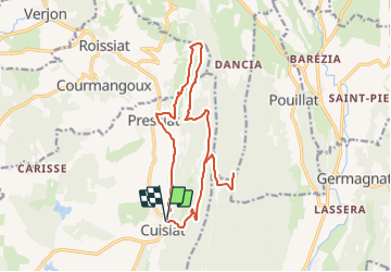

Length
16.4 km

Max alt
767 m

Uphill gradient
787 m
Km-Effort
27 km

Min alt
338 m

Downhill gradient
788 m
Boucle
Yes
Creation date :
2021-09-04 06:05:04.081
Updated on :
2021-09-04 06:05:58.644
--
Difficulty : Very easy

FREE GPS app for hiking
 SityTrail
IGN / Geographical institutes
SityTrail Plus
The world is yours!
About
Trail Trail of 16.4 km to be discovered at Auvergne-Rhône-Alpes, Ain, Val-Revermont. This trail is proposed by CLP01.
Positioning
Country:
France
Region :
Auvergne-Rhône-Alpes
Department/Province :
Ain
Municipality :
Val-Revermont
Location:
Unknown
Start:(Dec)
Start:(UTM)
683973 ; 5130241 (31T) N.
Comments