


2021-09-04_10h15m01_Marchanp_V1

daniellebou
User
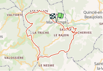

Length
19.7 km

Max alt
789 m

Uphill gradient
761 m
Km-Effort
30 km

Min alt
333 m

Downhill gradient
758 m
Boucle
Yes
Creation date :
2021-09-04 08:15:01.597
Updated on :
2021-09-10 09:03:19.244
6h47
Difficulty : Very difficult

FREE GPS app for hiking
 SityTrail
IGN / Geographical institutes
SityTrail Plus
The world is yours!
About
Trail Walking of 19.7 km to be discovered at Auvergne-Rhône-Alpes, Rhône, Marchampt. This trail is proposed by daniellebou.
Positioning
Country:
France
Region :
Auvergne-Rhône-Alpes
Department/Province :
Rhône
Municipality :
Marchampt
Location:
Unknown
Start:(Dec)
Start:(UTM)
621452 ; 5107726 (31T) N.
Comments