


pruniers ecorando

lecmic
User
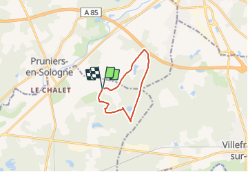

Length
8.2 km

Max alt
112 m

Uphill gradient
64 m
Km-Effort
9.1 km

Min alt
90 m

Downhill gradient
63 m
Boucle
Yes
Creation date :
2021-09-04 07:30:11.674
Updated on :
2021-09-04 09:50:28.377
2h19
Difficulty : Medium

FREE GPS app for hiking
 SityTrail
IGN / Geographical institutes
SityTrail Plus
The world is yours!
About
Trail Walking of 8.2 km to be discovered at Centre-Loire Valley, Loir-et-Cher, Gièvres. This trail is proposed by lecmic.
Description
rando avec ramassage dechets
Positioning
Country:
France
Region :
Centre-Loire Valley
Department/Province :
Loir-et-Cher
Municipality :
Gièvres
Location:
Unknown
Start:(Dec)
Start:(UTM)
401592 ; 5240936 (31T) N.
Comments