


Linéaire depuis Pfaffenbronn.

VANDERPUTTENMi
User GUIDE
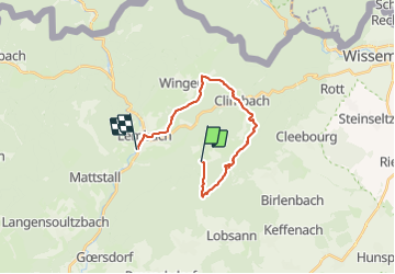

Length
16.9 km

Max alt
502 m

Uphill gradient
414 m
Km-Effort
23 km

Min alt
187 m

Downhill gradient
553 m
Boucle
No
Creation date :
2021-09-04 07:09:29.055
Updated on :
2021-10-02 13:23:19.122
4h26
Difficulty : Very difficult

FREE GPS app for hiking
 SityTrail
IGN / Geographical institutes
SityTrail Plus
The world is yours!
About
Trail Walking of 16.9 km to be discovered at Grand Est, Bas-Rhin, Lembach. This trail is proposed by VANDERPUTTENMi.
Photos

Positioning
Country:
France
Region :
Grand Est
Department/Province :
Bas-Rhin
Municipality :
Lembach
Location:
Unknown
Start:(Dec)
Start:(UTM)
414084 ; 5427346 (32U) N.
Comments