


chambost 4.9.2021

maclobar
User
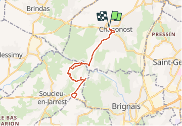

Length
15 km

Max alt
332 m

Uphill gradient
285 m
Km-Effort
18.8 km

Min alt
232 m

Downhill gradient
284 m
Boucle
Yes
Creation date :
2021-09-04 08:18:51.023
Updated on :
2021-09-04 15:08:56.603
5h16
Difficulty : Difficult

FREE GPS app for hiking
 SityTrail
IGN / Geographical institutes
SityTrail Plus
The world is yours!
About
Trail Walking of 15 km to be discovered at Auvergne-Rhône-Alpes, Rhône, Chaponost. This trail is proposed by maclobar.
Description
retour. pas de trajet sur la départementale. dangereux
Positioning
Country:
France
Region :
Auvergne-Rhône-Alpes
Department/Province :
Rhône
Municipality :
Chaponost
Location:
Unknown
Start:(Dec)
Start:(UTM)
635651 ; 5063468 (31T) N.
Comments
agréable randonnée mais AR imprévu du fait d'un passage de 4km proposé sur une départementale très passante en direction de Brignais. sinon rivière et ombragée.