


Sentier brossous

iznogud
User
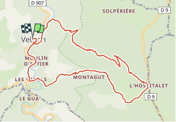

Length
13.9 km

Max alt
1066 m

Uphill gradient
487 m
Km-Effort
20 km

Min alt
628 m

Downhill gradient
491 m
Boucle
Yes
Creation date :
2021-09-04 08:36:16.0
Updated on :
2021-09-04 21:00:46.063
6h46
Difficulty : Very difficult

FREE GPS app for hiking
 SityTrail
IGN / Geographical institutes
SityTrail Plus
The world is yours!
About
Trail Walking of 13.9 km to be discovered at Occitania, Lozère, Vebron. This trail is proposed by iznogud.
Description
Avec variante variété de paysage . Pas de grosse difficulté
Positioning
Country:
France
Region :
Occitania
Department/Province :
Lozère
Municipality :
Vebron
Location:
Unknown
Start:(Dec)
Start:(UTM)
546167 ; 4898611 (31T) N.
Comments