


Buvrinnes 04 09 21

andremusin
User
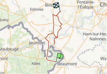

Length
59 km

Max alt
191 m

Uphill gradient
546 m
Km-Effort
66 km

Min alt
119 m

Downhill gradient
552 m
Boucle
No
Creation date :
2021-09-04 14:32:37.0
Updated on :
2021-09-05 05:43:52.91
2h33
Difficulty : Easy

FREE GPS app for hiking
 SityTrail
IGN / Geographical institutes
SityTrail Plus
The world is yours!
About
Trail Trail of 59 km to be discovered at Hauts-de-France, Nord, Cousolre. This trail is proposed by andremusin.
Photos

Positioning
Country:
France
Region :
Hauts-de-France
Department/Province :
Nord
Municipality :
Cousolre
Location:
Unknown
Start:(Dec)
Start:(UTM)
584700 ; 5565950 (31U) N.
Comments